Ground Penetrating Radar Method for Estimating Peat Thickness and Volume: Case Study in Kubu Raya, Indonesia
DOI:
https://doi.org/10.22452/mjs.vol45no1.6Keywords:
electromagnetic wave, ground penetrating radar, peat thickness and volumeAbstract
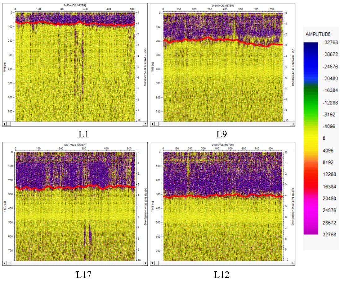
Tropical peatlands in Indonesia are very large, covering an area of about 13.4-14.9 million hectares. Kubu Raya District, West Kalimantan, is known to have significant natural resources and large regions of peatland. This research aims to estimate the thickness and volume of peat soil in the Rasau Jaya and Sungai Raya sub-districts of Kubu Raya Regency. This research uses the Ground Penetrating Radar (GPR) method, using the Plug-In Cobra GPR SE70 tool with a frequency of 80 MHz. This research applies 23 tracks and validation by three drill points, consisting of nine tracks in Sungai Raya District and 14 tracks in Rasau Jaya District. GPR data is processed through several processes: static correction, dewow, Butterworth bandpass, background removal, gain, subtracting average, and horizon picking. The results showed that the subsurface electromagnetic wave propagation speed at the research location was 0.026 m/ns, having a peat thickness of 0.8-4.2m. The deepest peat layer is in the east, having a thickness of 3.8-4.2m, while the shallowest peat layer is in the west, having a thickness of 0.8-1.1m. The results also show that the volume of peat in the research location is 4.8×10⁷ m3
References
Beucher, A., Koganti, T., Iversen, B. V., & Greve, M. H. (2020). Mapping of Peat Thickness Using a Multi-Receiver Electromagnetic Induction Instrument. Remote Sensing, 12(15), 1–21. https://doi.org/10.3390/RS12152458
Damanik, Z., Jaya, A., Radjagukguk, B., & Adam, C. (2024). Influence of Water Table and Peat Thickness on Dissolved Organic Carbon of Tropical Peat Soil with Sulfidic Substratum from Central Kalimantan, Indonesia. Journal of Multidisciplinary Applied Natural Science, 4(1), 76–89. https://doi.org/10.47352/jmans.2774-3047.189
Fiantis, D., Rudiyanto, Ginting, F. I., Agtalarik, A., Arianto, D. T., Wichaksono, P., Irfan, R., Nelson, M., Gusnidar, G., Jeon, S., & Minasny, B. (2024). Mapping Peat Thickness and Carbon Stock of a Degraded Peatland in West Sumatra, Indonesia. Soil Use and Management, 40(1), 1–13. https://doi.org/10.1111/sum.12954
Knödel, K., Lange, G., & Voigt, H.-J. (2007). Ground Penetrating Radar (1st ed.). Springer Berlin, Heidelberg. https://doi.org/https://doi.org/10.1007/978-3-540-74671-3
Koyan, P., Tronicke, J., Klose, T., & Guillemoteau, J. (2023). 3D GPR to Explore Peat Deposits: Strategies for Data Acquisition, Processing, and Interpretation. 12th International Workshop on Advanced Ground Penetrating Radar, (IWAGPR), 1–4. https://doi.org/10.1109/IWAGPR57138.2023.10329077
Mbango, F. M., Bouesse, G. F., & Ndagijimana, F. (2022). Extraction of the Complex Relative Permittivity from the Characteristic Impedance of Transmission Line by Resolving Discontinuities. Electronics (Switzerland), 11(23), 1–15. https://doi.org/10.3390/electronics11234035
Nizam, A. M. A. H., Taib, M. S., Yunus, M. N. Z., & Saman, N. (2023). Assessment of Peat Fire Susceptibility for Carbon Emission Reduction. IOP Conference Series: Earth and Environmental Science, 1144(012014), 1–8. https://doi.org/10.1088/1755-1315/1144/1/012014
Pezdir, V., Čeru, T., Horn, B., & Gosar, M. (2021). Investigating Peatland Stratigraphy and Development of the Šijec Bog (Slovenia) Using Near-Surface Geophysical Methods. Catena, 206(105484), 1–15. https://doi.org/10.1016/j.catena.2021.105484
Putri, T. T. A. (2017). Pengelolaan Sumberdaya Lahan Gambut di Kubu Raya Kalimantan Barat Menuju Lahan Tanpa Bakar. Jurnal Penelitian Agrosamudra, 4(2), 92–109.
Rais, R., Muhardi, & Siregar, H. E. A. (2024). Analisis Tingkat Kematangan Gambut Berdasarkan Refleksi Radargram di Kecamatan Rasau Jaya Kabupaten Kubu Raya. Prisma Fisika, 12(1), 25–29.
Ryazantsev, P. A., & Ignashov, P. A. (2022). Integrating TDR and GPR Methods to Study The Structure of Peatland. Limnology and Freshwater Biology, 5(4), 1556–1558. https://doi.org/10.31951/2658-3518-2022-A-4-1556
Sinyutkina, A. (2021). Investigating Peat Deposits with Ground Penetrating Radar-A Case Study of Drained Bogs in Western Siberia, Russia. E3S Web of Conferences, 258, 1–7. https://doi.org/10.1051/e3sconf/202125812007
Sumargana, L., Frederik, M., Sumirah, & Nugroho, D. (2019). Ground Penetrating Radar Mapping of Peat Depth at Burnai-Sibumbung Rivers Peatland Hydrological Unit Ogan Komering Ilir Regency. 2nd IEEE Asia-Pacific Conference on Geoscience, Electronics and Remote Sensing Technology (AGERS), 15–18. https://doi.org/10.1109/AGERS48446.2019.9034262
Suryani, E., Pratamaningsih, M. M., Muslim, R. Q., Erwinda, Hati, D. P., Kricella, P., Nugroho, E. S., Subandiono, R. E., & Anda, M. (2022). Variations in Peat Soil Properties at the West Coast of Sumatra Island. IOP Conference Series: Earth and Environmental Science, 1025(012025), 1–11. https://doi.org/10.1088/1755-1315/1025/1/012025
Tampubolon, B., Harjanti, D. T., Adlika, N. M., & Hari, M. L. C. (2020). Pemanfaatan Lahan Gambut Menjadi Lahan Potensial untuk Menjaga Ketahanan Pangan di Kalimantan Barat. Geodika: Jurnal Kajian Ilmu Dan Pendidikan Geografi, 4(2), 182–191. https://doi.org/10.29408/geodika.v4i2.2765
Tanjung, M. I., Sadikin, N., & Indrawan, D. (2017). Foundation Technology Development of Hydraulic Structure on Peat Soil. Jurnal Teknik Hidraulik, 7(2), 115–130.
Vernimmen, R., Hooijer, A., Akmalia, R., Fitranatanegara, N., Mulyadi, D., Yuherdha, A., Andreas, H., & Page, S. (2020). Mapping Deep Peat Carbon Stock from a LiDAR based DTM and Field Measurements, with Application to Eastern Sumatra. Carbon Balance and Management, 15(1), 1–18. https://doi.org/10.1186/s13021-020-00139-2
Wahab, A., Hasan, M., Kusin, F. M., Embong, Z., Zaman, Q. U., Babar, Z. U., & Imran, M. S. (2022). Physical Properties of Undisturbed Tropical Peat Soil at Pekan District, Pahang, West Malaysia. International Journal of Integrated Engineering, 14(4), 403–414. https://doi.org/10.30880/ijie.2022.14.04.031
Word, C. S., McLaughlin, D. L., Strahm, B. D., Stewart, R. D., Varner, J. M., Wurster, F. C., Amestoy, T. J., & Link, N. T. (2022). Peatland Drainage Alters Soil Structure and Water Retention Properties: Implications for Ecosystem Function and Management. Hydrological Processes, 36(3), 1–12. https://doi.org/10.1002/hyp.14533
Wu, S., Wang, L., Zeng, X., Wang, F., Liang, Z., & Ye, H. (2022). UAV-Mounted GPR for Object Detection Based on Cross-Correlation Background Subtraction Method. Remote Sensing, 14(20), 1–20. https://doi.org/10.3390/rs14205132
Yuwati, T. W., Rachmanadi, D., Pratiwi, Turjaman, M., Indrajaya, Y., Nugroho, H. Y. S. H., Qirom, M. A., Narendra, B. H., Winarno, B., Lestari, S., Santosa, P. B., Adi, R. N., Savitri, E., Putra, P. B., Wahyuningtyas, R. S., Prayudyaningsih, R., Halwany, W., Nasrul, B., Bastoni, & Mendham, D. (2021). Restoration of Degraded Tropical Peatland in Indonesia: A Review. Land, 10(11), 1–31. https://doi.org/10.3390/land10111170
Zhang, L., Ling, T., Yu, B., Huang, F., & Zhang, S. (2021). Intensive Interferences Processing for GPR Signal Based on the Wavelet Transform and F-K Filtering. Journal of Applied Geophysics, 186(104273), 1-9. https://doi.org/10.1016/j.jappgeo.2021.104273
Zhang, S., Liu, G., Chen, S., Rasmussen, C., & Liu, B. (2021). Assessing Soil Thickness in a Black Soil Watershed in Northeast China Using Random Forest and Field Observations. International Soil and Water Conservation Research, 9(1), 49–57. https://doi.org/10.1016/j.iswcr.2020.09.004
Zhou, L., Yu, D., Wang, Z., & Wang, X. (2019). Soil Water Content Estimation Using High-Frequency Ground Penetrating Radar Ligang. Water (Switzerland), 11(5), 1–16. https://doi.org/10.3390/w11051036
Downloads
Published
Issue
Section
License
Copyright (c) 2026 Malaysian Journal of Science (MJS)

This work is licensed under a Creative Commons Attribution-NonCommercial 4.0 International License.
Transfer of Copyrights
- In the event of publication of the manuscript entitled [INSERT MANUSCRIPT TITLE AND REF NO.] in the Malaysian Journal of Science, I hereby transfer copyrights of the manuscript title, abstract and contents to the Malaysian Journal of Science and the Faculty of Science, University of Malaya (as the publisher) for the full legal term of copyright and any renewals thereof throughout the world in any format, and any media for communication.
Conditions of Publication
- I hereby state that this manuscript to be published is an original work, unpublished in any form prior and I have obtained the necessary permission for the reproduction (or am the owner) of any images, illustrations, tables, charts, figures, maps, photographs and other visual materials of whom the copyrights is owned by a third party.
- This manuscript contains no statements that are contradictory to the relevant local and international laws or that infringes on the rights of others.
- I agree to indemnify the Malaysian Journal of Science and the Faculty of Science, University of Malaya (as the publisher) in the event of any claims that arise in regards to the above conditions and assume full liability on the published manuscript.
Reviewer’s Responsibilities
- Reviewers must treat the manuscripts received for reviewing process as confidential. It must not be shown or discussed with others without the authorization from the editor of MJS.
- Reviewers assigned must not have conflicts of interest with respect to the original work, the authors of the article or the research funding.
- Reviewers should judge or evaluate the manuscripts objective as possible. The feedback from the reviewers should be express clearly with supporting arguments.
- If the assigned reviewer considers themselves not able to complete the review of the manuscript, they must communicate with the editor, so that the manuscript could be sent to another suitable reviewer.
Copyright: Rights of the Author(s)
- Effective 2007, it will become the policy of the Malaysian Journal of Science (published by the Faculty of Science, University of Malaya) to obtain copyrights of all manuscripts published. This is to facilitate:
- Protection against copyright infringement of the manuscript through copyright breaches or piracy.
- Timely handling of reproduction requests from authorized third parties that are addressed directly to the Faculty of Science, University of Malaya.
- As the author, you may publish the fore-mentioned manuscript, whole or any part thereof, provided acknowledgement regarding copyright notice and reference to first publication in the Malaysian Journal of Science and Faculty of Science, University of Malaya (as the publishers) are given. You may produce copies of your manuscript, whole or any part thereof, for teaching purposes or to be provided, on individual basis, to fellow researchers.
- You may include the fore-mentioned manuscript, whole or any part thereof, electronically on a secure network at your affiliated institution, provided acknowledgement regarding copyright notice and reference to first publication in the Malaysian Journal of Science and Faculty of Science, University of Malaya (as the publishers) are given.
- You may include the fore-mentioned manuscript, whole or any part thereof, on the World Wide Web, provided acknowledgement regarding copyright notice and reference to first publication in the Malaysian Journal of Science and Faculty of Science, University of Malaya (as the publishers) are given.
- In the event that your manuscript, whole or any part thereof, has been requested to be reproduced, for any purpose or in any form approved by the Malaysian Journal of Science and Faculty of Science, University of Malaya (as the publishers), you will be informed. It is requested that any changes to your contact details (especially e-mail addresses) are made known.
Copyright: Role and responsibility of the Author(s)
- In the event of the manuscript to be published in the Malaysian Journal of Science contains materials copyrighted to others prior, it is the responsibility of current author(s) to obtain written permission from the copyright owner or owners.
- This written permission should be submitted with the proof-copy of the manuscript to be published in the Malaysian Journal of Science
Licensing Policy
Malaysian Journal of Science is an open-access journal that follows the Creative Commons Attribution-Non-commercial 4.0 International License (CC BY-NC 4.0)
CC BY – NC 4.0: Under this licence, the reusers to distribute, remix, alter, and build upon the content in any media or format for non-commercial purposes only, as long as proper acknowledgement is given to the authors of the original work. Please take the time to read the whole licence agreement (https://creativecommons.org/licenses/by-nc/4.0/legalcode ).


